"ROUTE OF PARKS": Chile’s Model for the World
Text & Photos: Justin Lotak · 10 min read
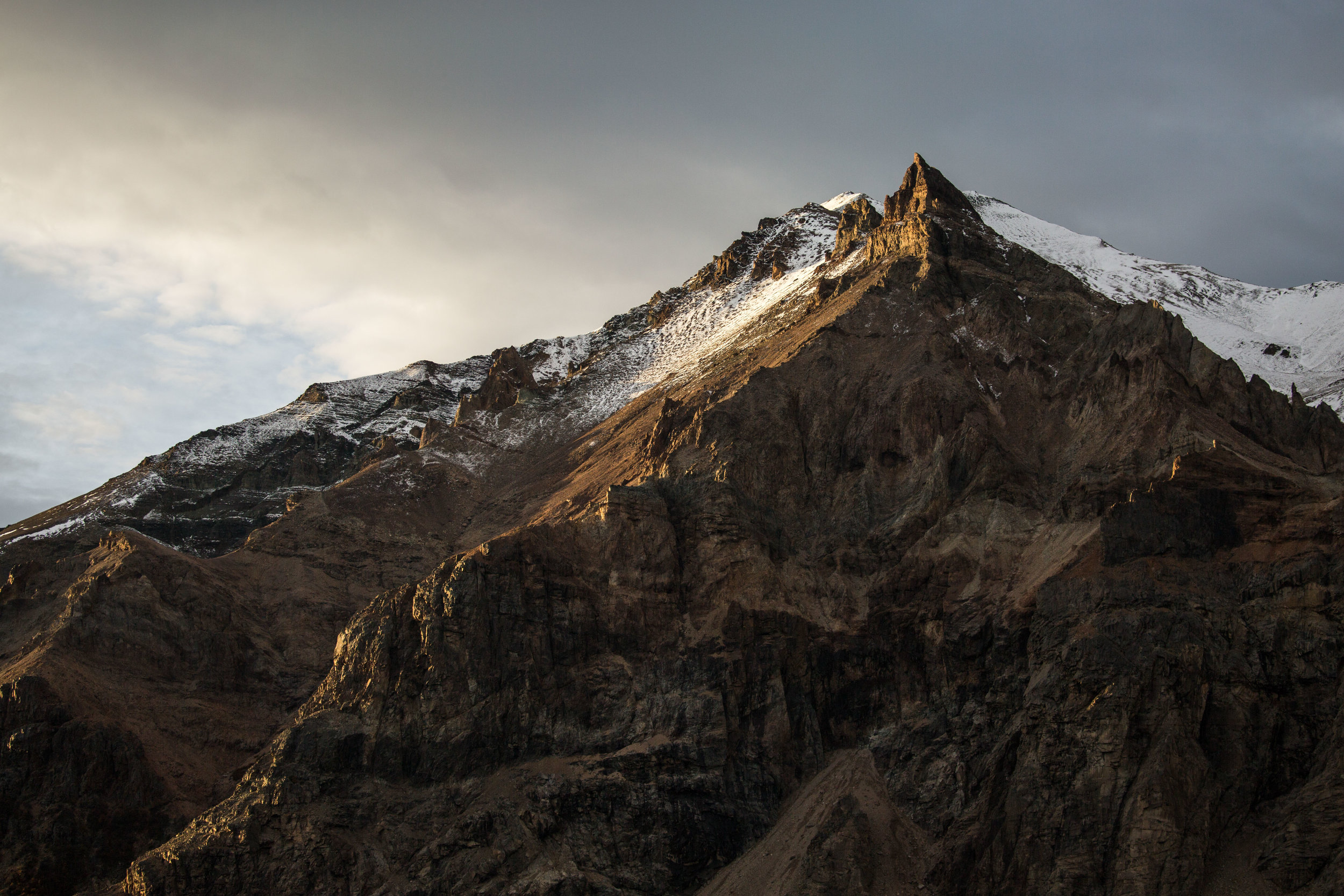
Peak in the Jeinimeni National Reserve, now part of Patagonia National Park
Over the last few decades, a major effort has been in the works to create one of the world’s greatest natural wonders: a connected system of national parks through one of the planet’s great wildernesses. Chile’s Route of Parks, or Ruta de los Parques, will create a chain of 17 national parks, crossing 1,500 miles of Chile, from the northern Valdivian temperate rainforests of Patagonia, to the windswept southern reaches of the continent on Tierra del Fuego and Cape Horn.
This effort will add 11 million acres of protected land to Chile’s national park system, one million of which will be private land donations from Tompkins Conservation, an organization that has been working to create national parks throughout Chile and Argentina. Large stretches of pristine ecosystems that include flora and fauna found nowhere else on the planet will be protected into the future, and local economies will grow from new opportunities for sustainable tourism. This initiative will become a model for the rest of the world; it is projected to bring $270 million annually in tourism revenue to the region and provide 43,000 jobs, showing that large scale conservation and healthy local economies can go hand-in-hand.
While traveling throughout Chilean Patagonia, we had the chance to see 11 of these current or future national parks, some of which in great depth. The route is long, and it would be difficult to see all these places in one trip. But the biodiversity, the opportunities for adventure, and the pristine beauty of the projects included in the Route of Parks will bring return visitors from throughout the world back to Patagonia again and again.
Here is a summary of the 17 current or future national parks that make up Chile’s Route of Parks. Five of these (Alacalufes, Cerro Castillo, Melimoyu, Patagonia, and Pumalín) will be new national parks, and three existing national parks (Corcovado, Hornopirén, and Isla Magdalena) will be expanded as part of this initiative.
1. PARQUE NACIONAL ALERCE ANDINO
At the very northern end of the Route of Parks lies Alerce Andino National Park. It covers 151 mi², and about half of its area protects the endangered alerce tree (Fitzroya cupressoides), which almost went extinct in the 20th century. These trees can grow to over 220 feet tall and are some of the oldest living trees today. The park can be reached via a short drive from Puerto Montt or Puerto Varas, and it hosts a variety of trails and campgrounds.

ALERCE (Fitzroya cupressoides)
A close-up of one of the many alerce, or larch trees in Alerce Andino National Park. Alerces can be thousands of years old, second only to the bristlecone pine tree in terms of oldest known tree species.
2. PARQUE NACIONAL HORNOPIRÉN
Created in 1988, Hornopirén National Park is a 186 mi² protected area of lush temperate rainforest and rugged mountains. There are glaciers, volcanos, three primary lakes, and six main rivers. The park hosts 18 threatened species as well as pristine alerce forests, though studies regarding the park's species have been sparse and further research is needed. From the town of Hornopirén (where the park's administration office is located), southeast of Puerto Montt, one would need to go approximately 7 miles to Chaqueihua via car or bus (when available), and then enter into the park on foot via a 4.5 mile rugged dirt road. Once in the park, there is a trail of 1.8 miles to get to Lago Pinto Concha, and from there one can continue another 2.2 miles to the Yates Volcano. Note that these lush rainforests grow fast and this can complicate the accessibility of the trails - check with park staff for trail conditions before departing.
3. PARQUE NACIONAL PUMALÍN - DOUGLAS TOMPKINS
Pumalín Park will become one of Chile’s national parks in the future, and probably one of its greatest. Just south of Hornopirén NP, the 1,115 mi² Pumalín Park is the first of the large-scale Tompkins Conservation projects. Steep forest-covered fiords, lush temperate rainforests, glacial-topped volcanoes, and gushing waterfalls will be almost everywhere you look. Pumalín can be accessed from the north (Caleta Gonzalo) or from the south (Chaitén), both of which have bus service to and from. Chaitén also occasionally has a ferry service that crosses the Gulf of Corcovado from Chiloé. The town of Chaitén has plenty of lodging options, and the park’s beautiful lodge at Caleta Gonzalo deserves a visit. Well-built trails and campgrounds can be found throughout the park, but go with the expectation of getting wet – this region receives over six meters of rain per year!

WATERFALL IN PUMALÍN
One of the many waterfalls in the future Pumalín National Park. The rain, fog, mists, and lush tree-covered mountains make for incredible photography opportunities, assuming you can keep your camera dry.
4. PARQUE NACIONAL CORCOVADO
Corcovado National Park lies a little further south from Pumalín, and was one of the conservation projects donated by Tompkins Conservation to Chile’s national park system. The Corcovado Volcano is the centerpiece of the park, and lush and dense temperate rainforests cover most of the 1,135 mi² of land. The wildlife-rich park hosts 18 species of mammal, 64 bird species and 133 flora species, including the largest stand of Guaitecas cypress trees in Chile. There is currently no infrastructure within the park, but prospective visitors can ask tour companies in Chaitén for options to possibly access the coastlines via boat. Check out the film 180˚ South to see Yvon Chouinard and friends visit this park during the film’s creation, which was partly retracing Yvon Chouinard and Doug Tompkins’ legendary 1968 trip from California to Patagonia.
5. FUTURO PARQUE NACIONAL MELIMOYU
The future Melimoyu National Park is another Tompkins Conservation project, consisting of canals, fiords and islands, also in Chile’s temperate rainforest region. Above the forest sits the active Melimoyu stratovolcano, with an 8-km-wide ice-filled caldera, which rises 8,010 feet above sea level. The park lies 25 miles northwest of the town of Puyuhuapi, and 82 miles south of the town of Chaitén.
6. PARQUE NACIONAL QUEULAT
A short drive south from Puyuhuapi, or a few hours north from Coyhaique lies the impressive 958 mi² Queulat National Park. There are not a lot of trails here, but the ones that do exist deserve a visit. The Sendero Bosque Encantado, or Enchanted Forest Trail (~2 hours roundtrip, though you’ll want to spend some time in the valley) and the Sendero Ventisquero Colgante, or Hanging Glacier Trail (~3 hours, 6km roundtrip) are arguably some of Patagonia’s best day hikes. The forest truly seems enchanted, and the pristine valleys with waterfalls and hanging glaciers will bring out the inner kid in anyone that has the opportunity to visit this impressive national park.

WATERFALL IN QUEULAT NATIONAL PARK
Rugged peaks, multiple waterfalls, and glaciers await those at the valley at the end of the Enchanted Forest Trail, in Queulat National Park.
7. PARQUE NACIONAL ISLA MAGDALENA
The remote Isla Magdalena National Park is located on an island off the coast of Puerto Cisnes, and protects 609 mi² of this wild Patagonian island and its smaller surrounding islands. It became a national park in 1983 and protects several species, including otters, pudus, sea lions, petrels, and a colony of thousands of Magellanic penguins. The highest point of the island is Mentolat Volcano, at 5,453 ft. There is currently no infrastructure in the national park, but it can be visited via tours from Puerto Cisnes or Puerto Puyuhuapi.
8. PARQUE NACIONAL LAGUNA SAN RAFAEL
Another large protected area in Chile, the Laguna San Rafael National Park protects 6,726 mi², including the Northern Patagonian Ice Field. The park was established in 1959 and became an UNESCO Biosphere Reserve in 1979. Rugged and mountainous, this park is home to glaciers, lakes, rivers, and some of Chilean Patagonia’s tallest peaks, including its tallest, Monte San Valentin, at 13,314 ft. The park can be accessed from Coyhaique and Puerto Rio Tranquilo, and it offers backpacking, mountaineering, mountain climbing, kayaking, and skiing.
EXPLORADORES VALLEY, LAGUNA SAN RAFAEL NATIONAL PARK
On the north side of Laguna San Rafael National Park is the Exploradores Valley, easily accessible from the town of Puerto Rio Tranquilo.
9. FUTURO PARQUE NACIONAL CERRO CASTILLO
The current Cerro Castillo National Reserve at 639 mi² will change to national park status, continuing its protection of the rugged mountains between Coyhaique and Lago General Carrera. This incredible mountainous landscape offers adventurers limitless possibilities for backpacking, rock climbing, and mountaineering. Its peaks include Cerro Iglesia (5,741 ft) and Cerro Castillo (7,612 ft), and there are several well-built trails throughout the area, including the 34-mile Cerro Castillo Circuit (estimate 3-4 days, and bring a map). Easily accessible from the city of Coyhaique, this future national park will surely grow on the radars of many, and its picturesque peaks are a magical place to visit.

CERO CASTILLO NATIONAL PARK
A view of Cerro Castillo from lake General Carrera
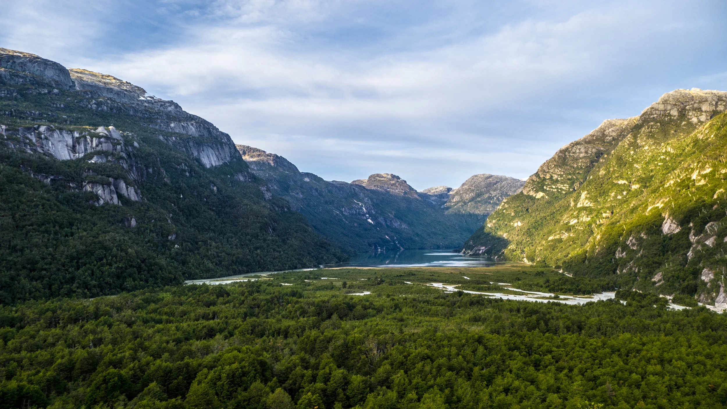
10. FUTURO PARQUE NACIONAL PATAGONIA
A few hours south of Coyhaique, just northeast of the town of Cochrane, lies the future Patagonia National Park. This impressive project by Conservacion Patagonica has been in the works since the former estancia in the Chacabuco Valley, an overgrazed sheep ranch, was purchased in 2004. The future national park will eventually protect 1,016 mi² by combining the Jeinimeni National Reserve to the north and the Tamango National Reserve to the south with the Chacabuco Valley in between. For the last decade, park staff and volunteers have been working to build high quality trails and park facilities, remove invasive species, and bring back some of the native wildlife such as guanacos, ñandús, pumas, Andean condors, and huemuls. The openness of the Chacabuco Valley makes wildlife viewing easy in this reserve, and the variety of trails offer impressive views of the unique steppe ecosystem and surrounding rugged mountains. We’ve covered this project in depth with a variety of posts on our blog, including its biodiversity, trails, organic garden, park facilities, its ñandú conservation program, as well as a description of traversing the park during an eight-day backpacking trip.

GUANACO HERD IN PATAGONIA NATIONAL PARK
Guanacos (Lama guanicoe) are a type of camelid native to South America, and a common presence in the Patagonia National Park due to the comeback of the grasslands and steppe habitats, as well as to the removal of fences by the park’s staff and volunteers.
11. PARQUE NACIONAL BERNARDO O’HIGGINS
At 13,614 mi², Bernardo O’Higgins National Park is the largest national park in Chile. Yet, despite its size, it is almost inaccessible. There is a small trail that leads to a glacier that one can reach by ferry tours from Puerto Natales, or one can take the long ferry services from Puerto Natales to Caleta Tortel or Puerto Montt, which winds through the wild fiords of Bernardo O’Higgins. Much of it is covered by a giant mass of ice: the Southern Patagonian Ice Field, with the rest being mostly wild and pristine forests, mountains and coastline. This is great for the wildlife of the region, including the endangered huemul, or south Andean deer, as this national park is one of its last remaining refuges. For wilder excursions, there are options to visit the park from the village of O’Higgins, all the way at the southern end of the Carretera Austral.
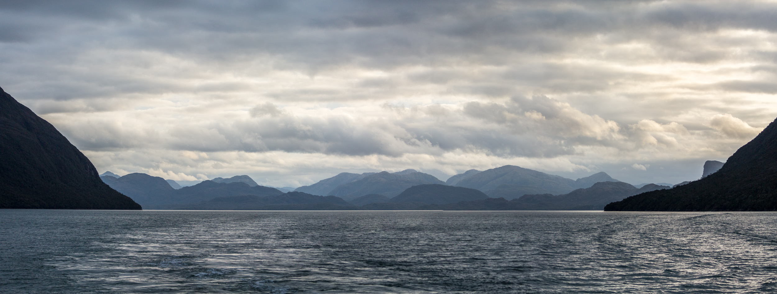
THE RUGGED COAST OF THE BERNARDO O’HIGGINS NATIONAL PARK SEEN FROM THE FERRY
Bernardo O'Higgins National Park covers an immense area of islands, channels and fiords, many of which are visible from ferry crossings that travel north and south through Patagonia.
12. FUTURO PARQUE NACIONAL ALACALUFES
Currently an 8,934 mi² national reserve, this large area of fiords and islands will get an upgrade to national park status in the near future. The future Alacalufes National Park includes large swaths of wild Patagonia coastal grasslands, thickets, peat moss, and Coihue forests. Although difficult to access, one great option for viewing the fiords and channels of Alacalufes is from the ferry service that travels between Puerto Montt and Puerto Natales, or between Caleta Tortel and Puerto Natales.

the remote alacalufes national park
Passing through the fiords of the future Alacalufes National Park, with constant rain and glimpses of glaciers when the clouds permit.
13. PARQUE NACIONAL TORRES DEL PAINE
The 700 mi² Torres del Paine National Park probably does not need an introduction. This is one of the most visited national parks in all South America, which will likely turn off many, but the crowds are there for a reason. The Paine Massif at the center of the park seems to represent wild Patagonia and all its moods as the weather changes from perfect blue skies and sunshine to foreboding gray clouds and sideways rain. In 2016, limits were put in place for the quantity of people that can enter the park at a time, and one must now apply for permits well ahead of time. This is for the best, given the number of daily visitors that come, especially throughout the Austral summers. For a more secluded experience of Torres del Paine, consider coming in the winter – the snow and the cold will make for a different type of experience, plus it's usually less windy there in the winter. The park is accessible from the city of Puerto Natales, and the famous backpacking hikes are the “W” and the “Circuit”.

the world famous torres del paine national park
Purples, pinks, oranges and reds fill the sky during sunrise after a storm at Torres del Paine National Park.
14. PARQUE NACIONAL PALI-AIKE
Created in 1970, Pali-Aike National Park is a small conservation area, at 12,416 acres, and is a three-hour drive from Punta Arenas, or 4.5 hours from Puerto Natales. It lies on the border with Argentina and protects an archeological area with prehistoric remains. The landscape is other-worldly with its wildlife and volcanic craters mixed in with its relatively flat landscape. There are some trails with day hiking opportunities, and the park can be visited in one day.
15. PARQUE NACIONAL ALBERTO DE AGOSTINI
Alberto de Agostini is a huge, wild expanse in Tierra del Fuego and nearby islands, protecting 5,637 mi² of land. Its rugged snow-capped Cordillera Darwin can be seen on clear days from the Peninsula of Brunswick. This park, along with Cape Horn National Park, was declared a UNESCO Biosphere Reserve in 2005. Several marine mammals call the numerous fiords found throughout this protected area home, including southern elephant seals, leopard seals, toninas, Burmeister's porpoise, Peale's dolphin, and humpback whale. Although only 80 nautical miles from Punta Arenas, there are no roads to get to the park. Ferries to and from Puerto Williams and Punta Arenas cross through its many wild fiords, passing its glaciers and mountains.

ALBERTO DE AGOSTINI NATIONAL PARK AT THE BOTTOM OF SOUTH AMERICA
Monte Sarmiento, which is at the western end of the Cordillera Darwin within Alberto de Agostini National Park. Darwin called this "the most sublime spectacle in Tierra del Fuego".
16. PARQUE NACIONAL YENDEGAIA
One of Chile’s newest national parks is Yendegaia, which protects a 5,823 mi² conservation bridge between Chile’s Alberto de Agostini National Park and Argentina’s Tierra del Fuego National Park. This land was donated by Tompkins Conservation and became a national park in 2013. Currently a road is being built through the heart of the park, which will allow visitors to see much of this wild terrain via their vehicle, but there are adventures to be had throughout this large expanse of snow-capped mountains and river valleys. The surrounding seas are incredibly biodiverse, but know that the weather down here can be treacherous. It is not uncommon to see wind speeds in excess of 80 km/h, and backpackers should enter with caution. Also, if you plan to visit, check the current park status, as road construction activities have limited public access.

YENDEGAIA NATIONAL PARK
The clouds parting in Yendegaia Bay, letting light shine down on the Cordillera Darwin.
17. PARQUE NACIONAL CABO DE HORNOS
Cape Horn National Park is the southern-most national park in the world, created in 1945, and protects 244 mi². It is accessible via a 12-hour boat ride from Puerto Williams. This windy, remote group of islands is notorious for its weather and harsh conditions, reportedly receiving upwards of 278 days of rainfall per annum. For a sample of some of the flora that can be found here, consider visiting Omora Ethnobotanical Park just outside of Puerto Williams, and bring your macro lens. See the video below for some beautiful imagery of Cape Horn produced by National Geographic and their Pristine Seas initiative:


On a land destined to be logged, some of the most pristine valdivian temperate forests are now protected by this Nature Conservancy reserve. With its rugged coasts, ancient trees, impressive sand dunes, and local culture, it is a beautiful place to explore. Interview with Liliana Pezoa, administrator of the reserve.